Mount Pleasant Optimisation Project
Mount Pleasant Optimisation Project
The Optimisation Project was approved with conditions by the Independent Planning Commission on 6th September 2022. MACH Energy thanks all who made submissions. Further updates on development under SSD-10418 will be made in due course.
What does the Optimisation Project include?
The Optimisation Project would include:
- mining of additional coal reserves, including lower coal seams in North Pit;
- staged increase in extraction, handling and processing of run-of-mine (ROM) coal up to 21 million tonnes per annum as mining moves west, away from Muswellbrook;
- increase in average operational workforce to approximately 600 people, with a peak of approximately 830 people;
- giving up part of the approved disturbance area to compensate for new disturbance areas;
- rail transport of up to approximately 17 million tonnes per annum of product coal to domestic and export customers;
- use of innovative mine landform design to provide topographic relief and more natural exterior appearance of waste rock emplacement landforms;
- development of new water management and coal reject dewatering infrastructure;
- construction and operation of new ancillary infrastructure; and
- continuation of the Mount Pleasant Operation through to 22 December 2048.
The Project would provide community certainty for continuation of mining in the region and Mount Pleasant Operation’s continued support for local community groups and suppliers.
Mount Pleasant Optimisation Project Community Information Sessions


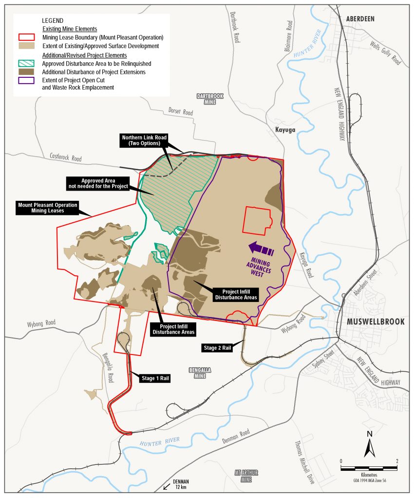
The following figure illustrates the approved area to be relinquished and Project extensions in the Mount Pleasant Operation Mining Leases. The Optimisation Project mining rate would be staged so it increases as mining moves further away from Muswellbrook.

State Significant Development Proposal – EIS
To enable the continuation of the Mount Pleasant Operation past 2026 we are required to submit a State Significant Development proposal.
As part of the proposal, we have prepared an Environmental Impact Statement (EIS) which includes assessments of the Optimisation Project’s potential social, economic and environmental impacts.
You can read more about the State Significant Development process on the NSW Government website.
Please visit the NSW Government Major Projects website to find information on the Optimisation Project, and associated NSW Government advice and requirements.
The Major Projects website Optimisation Project page includes the Optimisation Project EIS. The EIS exhibition period has now closed (17th March 2021). You can also download the EIS from our website using the link below.
Environmental Impact Statement (EIS)
5. Section 3 – Project Description
6. Section 4 – Strategic Context
7. Section 5 – Statutory Context
9. Section 7 – Environmental Assessment
10. Section 8 – Evaluation and Conclusion
12. Section 10 – Abb., Acronyms and Glossary
14. Att 2 – Assessment Requirements
15. Att 3 – Development Application Area and Real Property
16. Att 4 – Land Ownership and Landholder Key
17. Att 5 – Peer Review Letters
18. Att 6 – Strategic Planning Statements and Policies
19. Att 7 – Relevant Planning Instruments and Legislation
20. Att 8 – Rehabilitation and Mine Closure Addendum
21. Att 9 – Summary of Mitigation Measures
22. Att 10 – CIV Estimate Report
23. Att 11 – Consent under Section 380AA of Mining Act
24. Att 12 – JORC (2012) Summary
25. Att 13 – Geotechnical Considerations
26. Att 14 – Copy of Public Notice
27. Appendix A – Noise and Blasting Assessment
28. Appendix B – Air Quality Assessment
29. Appendix C – Groundwater Assessment
30. Appendix D – Surface Water Assessment
32. Appendix F – Aquatic Ecology Assessment
34. Appendix H – Historical Heritage Assessment
35. Appendix I – Agricultural and Land Resources Assessment
36. Appendix J – Road Transport Assessment
37. Appendix K – Geochemistry Assessment
38. Appendix L – Land Contamination Assessment
39. Appendix M – Visual and Landscape Assessment
40. Appendix N – Social Impact Assessment
41. Appendix O – Economic Assessment
42. Appendix P – Environmental Risk Assessment
43. Appendix Q – Preliminary Hazard Analysis
44. Appendix R – Human Health Assessment